Posts

Showing posts with the label trails

Master Naturalist Week 1
Image
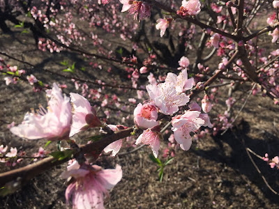
MN Week 1 Camp Discovery - Blythewood Not during our class but peach trees are starting to bloom! This past week, I began the Midlands Master Naturalist Program with the South Carolina Wildlife Federation and Clemson University.  “The Midlands Master Naturalist course is part of a statewide Master Naturalist Program coordinated by Clemson University.  The mission of the program is to create a corps of citizen volunteers well-trained in the fundamentals of natural history, nature interpretation, and the interface of humans and nature in order to empower them to contribute their time and talents to responsible, science-based environmental stewardship.  The Midlands course is hosted by the SCWF and taught by experts in the fields of natural history, botany, biology, forestry, and geology.” (from their website) I have heard about this program for a few years. Both of my parents participated in the Upstate class and have stayed involved with the program. Clas...

Clemson

Image
2020 Hiking Post 5 As a Gamecock fan, it can be hard to admit it but there are some nice spots for outdoor activities in Clemson. Since the school and town are located in the foothills of the mountains and there are many lakes in the area, trails and water activities are everywhere. Trail Map Just outside of the town of Clemson, is the Clemson Experimental Forest.   It is over 17,000 acres with miles of trails for hiking and mountain biking. It also borders part of Lake Hartwell. Many of the trails are mixed use but I had heard about a trail to a waterfall that was for hiking only. The Waldrop Stone Waterfall Trail is a short trail of about a mile that takes you along a creek to a couple of waterfalls. It has some challenging parts, where you have a steep descent to the waterfall (which means you have to hike back up that hill on the return), but they have built some steps and railings to help in sections. It’s also nice there are quite a few benches that you can ...

Battle of Rivers Bridge State Historic Site

Image
2020 Hiking Post 4 You might remember how last May, we visited the  Battle of Rivers Bridge State Historic Site . Recently, we returned there so we could explore the park more. This site is the only SC State Park where Confederate soldiers fought Sherman's troops as he made his way from Savannah to Columbia. There is a short trail (less than a mile) that takes you around the battleground and shows you the battle and what conditions were like at the time. There are still earthen rifle pits and other embankments that the soldiers built. Lots of informational signs along the way. Rifle pit mounds Retreat Trail There's also another trail that marks the route that the soldiers took as they retreated and a cemetery that has the dead from the battle. The park is free and has good visuals of how the battle took place and who was involved in it. There is also a community center and some neat events that take place throughout the year that show you what life wa...

Lake Conestee Nature Park

Image
2020 Hiking Post 3 Outside of Greenville, near the town of Mauldin, there is a wilderness oasis in the suburbs. I had heard about Lake Conestee Nature Park and driven by it before but I didn't realize it was so large (400 acres) with so many trails. The Swamp Rabbit Trail has a 4 mile section through this park which runs north, past the park, to connect with the section of the trail on Cleveland Street. (Be advised, there is a section that is not complete on the trail where you have to go along side traffic on Parkins Mill Rd.) This nature park has miles of paved and unpaved trails (about 12 miles) that take you around the Reedy River and Lake Conestee. Lake Conestee was a man-made lake on the river that was built for the Conestee Mill in the early 1800s. The dam and mill are still there but everything is gated off. Looks like there is talk of renovation but we'll see if that takes off. It would be a great location. Conestee Mill When we visited, on a Sunda...

Woods Bay State Park

Image
2020 Hiking Post 2 I mentioned previously that even though we've been to all of the South Carolina State Parks, there were a few that we wanted to return to. One of these was Woods Bay State Park . This small park is near the town of Olanta, east of Sumter and just east of I-95. The park is surrounding what is called a Carolina Bay. Carolina bays are elliptical depressions in the coastal area of the Mid-Atlantic. Local author Tom Poland has a new book out about the Carolina Bays that I'm excited to check out. From the description of his book: " The best definition of these features are "temporary, isolated freshwater wetlands," variously described as "high or flatwater ponds, wet weather lakes, or vernal pools," often identified more accurately as "pocosins," and they are ecological wonders, full of all manner of amphibians and reptiles, insects and birds, wildlife and plants--many of them exotic and rare. What also defines them is th...

SC State Parks Overview

Image
South Carolina State Parks Looking back over this past year and the many different state parks, it’s hard to say which park would be my favorite. There are a total of 47 state parks in South Carolina. The parks are so varied, I thought it would be best to do a list of superlatives instead. First, its probably helpful to talk about the different types of state parks we have. There are the beach parks that have beach access, camping, and they preserve the area as close as they can to its natural state. Then there are the mountain parks, which provide hiking, camping, and access to the mountains of the state. There are also many state parks that seem like their primary purpose is to provide a natural park for residents in the area to hike, camp, picnic, and have access to a lake or other body of water. Many of these parks have gathering spaces for the community to use. Finally, there are parks that preserve some part of the history of South Carolina. Many are plantation homes or sit...

Wateree Passage Part 1

Image
2020 Hiking #1 Happy New Year! We started off the new year with a new hike. It was a nice day here in South Carolina, clear and cool, so we decided to try a new section of the Palmetto Trail. I have wanted to hike the Wateree Passage since it's close to Columbia and crosses the Wateree River. The Wateree Passage is a little over 11 miles. It connects Highway 601 to Poinsett State Park where the High Hills of Santee Passage begins. We decided to start at the western end of the trail. It starts near Eastover on Highway 601, travels south along the highway for about 2.5 miles, then turns east and joins up with an old railroad bed to cross the Wateree River and the surrounding lowlands. Trailhead at Hwy. 601 The trail is pretty flat the whole way that we hiked. We crossed the Wateree River and hiked to the suspension bridge, which was about 4.25 miles. Our total hike was about 8.5 miles round trip. The section along 601 followed the highway but was in the trees. Some pa...

Cheraw State Park

Image
2019 Hiking Week 40 Cheraw State Park We're getting close to the end! Just four state parks left on our list! We recently checked off three parks in the northeast region of South Carolina. We explored the area and had fun visiting some new places. The three parks we visited were Little Pee Dee State Park , Cheraw State Park , and the H. Cooper Black Jr. Memorial Field Trial and Recreation Area.   Little Pee Dee State Park has a lake but the level has been lowered to make repairs on their dam. The H. Cooper Black Park is mostly for people with horses or hunting dogs. We spent the most time at Cheraw State Park. Cheraw State Park reminded us of Hickory Knob State Park. There is a golf course, a lake, lodging, and trails. When we arrived, it was cloudy, cool, and overcast, but as we walked around, the sun came out and it was really pretty. The park ranger was nice and helpful. We decided to walk the boardwalk around part of the lake to the spillway. We didn't realize tha...