Posts

Showing posts with the label birds

Master Naturalist Week 1
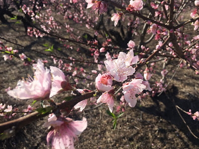
Image
MN Week 1 Camp Discovery - Blythewood Not during our class but peach trees are starting to bloom! This past week, I began the Midlands Master Naturalist Program with the South Carolina Wildlife Federation and Clemson University.  “The Midlands Master Naturalist course is part of a statewide Master Naturalist Program coordinated by Clemson University.  The mission of the program is to create a corps of citizen volunteers well-trained in the fundamentals of natural history, nature interpretation, and the interface of humans and nature in order to empower them to contribute their time and talents to responsible, science-based environmental stewardship.  The Midlands course is hosted by the SCWF and taught by experts in the fields of natural history, botany, biology, forestry, and geology.” (from their website) I have heard about this program for a few years. Both of my parents participated in the Upstate class and have stayed involved with the program. Clas...

Wateree Passage Part 1

Image
2020 Hiking #1 Happy New Year! We started off the new year with a new hike. It was a nice day here in South Carolina, clear and cool, so we decided to try a new section of the Palmetto Trail. I have wanted to hike the Wateree Passage since it's close to Columbia and crosses the Wateree River. The Wateree Passage is a little over 11 miles. It connects Highway 601 to Poinsett State Park where the High Hills of Santee Passage begins. We decided to start at the western end of the trail. It starts near Eastover on Highway 601, travels south along the highway for about 2.5 miles, then turns east and joins up with an old railroad bed to cross the Wateree River and the surrounding lowlands. Trailhead at Hwy. 601 The trail is pretty flat the whole way that we hiked. We crossed the Wateree River and hiked to the suspension bridge, which was about 4.25 miles. Our total hike was about 8.5 miles round trip. The section along 601 followed the highway but was in the trees. Some pa...

The Grand Strand

Image
Hiking 2019 Week 33 Myrtle Beach and the Grand Strand area of South Carolina is probably one of the most popular parts of the state. People have been flocking to the area for over 50 years to enjoy the beaches. Even though I grew up in Florida, my family would meet other family members in the summer at Pawleys Island. I remember staying on the beach, playing putt-putt golf, and setting off fireworks. Since moving to South Carolina, my family doesn’t visit Myrtle Beach as often. Since it’s about three hours from Columbia and Charleston is only about an hour and a half, we tend to go to Isle of Palms or other Charleston beaches. But there are two state parks in the Grand Strand area and one plantation state park just south of the area. We decided to do a day trip to visit all three. Myrtle Beach State Park Our first stop was Myrtle Beach State Park . It is an oasis in the middle of all the tourist areas of Myrtle Beach. You have a glimpse of what the area must have looke...

Devil's Fork State Park

Image
Hiking 2019 week 28 Devil’s Fork State Park is on Lake Jocassee, in the mountains of South Carolina. If you’re looking for a place to cool off, I recommend this lake. It’s one of the prettiest lakes in South Carolina. Lake Jocassee doesn’t have much development. Most of the shoreline is prohibited from development. Also, the park is one of the few access points to the lake. So the boat traffic is pretty low compared to nearby Lakes Keowee and Hartwell. Because of the cold water temperatures and the location of the lake, the water is very clear and blue. It’s refreshing on a hot day.  There are many ways to enjoy Devil’s Fork State Park and Lake Jocassee. The park has campgrounds, a boat ramp, a swimming area, and paddle rentals. There are also trails in the park for hiking. Recently, we rented a tandem kayak and set off from the park along the shoreline. There were quite a few others on paddle boards and kayaks too. We found a couple of places along the way that had beach ...

Swan Lake Iris Gardens

Image
2019 Hiking week 27 I'm excited to share with you a new place this week. Swan Lake Iris Gardens is a free park in the City of Sumter. Sumter is only about an hour's drive east of Columbia and has a cute, recently renovated downtown area. Just west of downtown is the Swan Lake Iris Gardens. It's a large park that was made out of a cypress swamp. There is a walking path around a small lake where eight different species of swans live. Some of these swans were brought here as early as the 1930's. The park is known for its iris that bloom in the spring. I had hoped to visit this past spring to see them but didn't make it out. There are various educational opportunities while walking around the lake, like a "Talking Tree Trail", which teaches you about the various trees, and a butterfly garden. There's even a braille garden and a chocolate garden (plants that are chocolate varieties, not made of chocolate!). This past weekend, we brought our l...

Afternoon Drives from Columbia

Image
2019 Hiking Week 26 Chester State Park & Musgrove Mill State Historic Site Horseshoe Falls at Musgrove Mill As I mentioned before, I enjoy little day trips around the area to see new places. The best is when you get there by back roads. One Sunday afternoon, we decided to take a short trip up north of Columbia on Highway 321 to Chester State Park . The park is about an hour's drive from Columbia, outside of the town of Chester. We were pleasantly surprised by the park. It has a nice sized lake that has no motor boats on it. You can rent kayaks and other small boats to go out on the lake or you can fish from the long boardwalk they have crossing a section of the lake. Fishing Bridge There are gathering spaces, campgrounds, and playgrounds for people to use. They also have a disc golf course . It was a pretty quiet park, especially for a Sunday in the summer. Most of the people we saw were fishing. There are also a couple of trails around the lake. ...

Highway 321

Image
2019 Hiking Week 22 One of my favorite back roads drives in South Carolina is Highway 321, from Columbia to Hardeeville. We take this highway whenever we go to Savannah. Even though I've grown up in a time when interstates are ubiquitous and everyone wants to get where they're going as soon as possible, there were times when my parents took me on back roads drives and weekend explorations. I remember some Sundays, after church, driving out to have lunch in Prosperity and exploring the towns around Lake Murray. These days, we turn to the highways of South Carolina whenever we can, especially when we expect traffic to be heavy on the interstates. Lately, I have enjoyed seeing these small towns that I usually only see as names on a map or an exit sign. You'll remember when we visited Lake Wateree, we also went through the town of Great Falls. Now I have a picture of the town when I see that name. Years ago, when travelling to Savannah, we started getting off the inter...

Saluda River

Image
2019 Hiking Week 21 Downtown Columbia from the Saluda This week I wanted to feature a great way to cool off in the South Carolina summer. Columbia has three rivers - the Saluda, and the Broad rivers which merge to form the Congaree River. When the summer heat is too hot to handle, the Saluda River is my favorite place to cool off. The water in the river comes from the bottom of Lake Murray which keeps it pretty cold even in the hottest days. There are many ways to access the river and cool off. The easiest is to visit Saluda Shoals Park and either kayak or tube through them. It's easy to rent the kayaks or tubes and they'll set you up with all you need. You put in at the west side of the park and then they will come pick you up at the east side of the park. It's not a far distance but it's a nice section to float down. The time will depend on how fast the water is flowing. If you want to create your own trip, there are a few boat ramps along the river that...

Swamp Rabbit Trail

Image
2019 Hiking Week 19 Many of you may have already heard about the Swamp Rabbit Trail in the Greenville area. The trail is said to be 22 miles long, with other side trails and extensions either completed or planned. The Swamp Rabbit was one of the first "rails-to-trails" I had been on but I now like to use it as much as possible. Currently, the trail runs from the south end of Greenville all the way to Travelers Rest. There is another small section of the trail south of I-85 around Lake Conestee. I like the Swamp Rabbit Trail because it is mostly flat and you can bike, walk, or run quite a few miles. I have used it in the past when training for half marathons. It's so helpful that they have mile markers along the way. Also, there are usually other people on the trail, even in the middle of winter. It can get pretty busy during the warmer months with families and groups out biking and walking. I recommend getting an early start if you want to avoid the crowds. Yea...